
- Explore
- Broadcast
- Activities
- Wildlife
- Historical Tours
- Cultural Tours
- Local Tours
- Adventure
- Blog
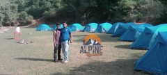
Rupin Pass is a high altitude trek which starts from Dhaula in Uttarakhand and ends at Sangla. Majorly you will do trekking in Himachal as 80% of the trek route is there itself.
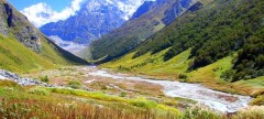
Being a high altitude trek, of about 15250 feet, Rupin Pass is considered among one of the high range expeditions for trekking in India. The high altitude in not just sole reason for its popularity among trekkers, the diversified number of sceneries and sudden variation in trails also attracts many nature lovers.
You will get surprised at every hour by the number of variety which mother nature has to offer you in Rupin Pass Trek. The trails at times are very difficult with its steep climbs which suddenly changes to an easy walks.
Rupin Pass is an ideal trek for any adventure as it offers trek to every type of terrain, be it on snow, rocky terrain, along and through the water streams or meadows. You will start trekking your route from greener and hot landscapes and move towards and through the coldest of areas over the snow as you reach to the end.
Surprises on the trek
Waterfalls views: You will encounter many waterfalls and stream though the trek. The best of the sights you will face at Rupin Valley which is of thousands of waterfalls flowing down through such a height that it appears as they are falling straight from the sky.
Jhaka Village, A Hanging Village: it is a unique positioned village at the utmost edge of the mountain making it appear to hanging through the cliff.
Snow Bridges:The feeling of walking on the snow bridges you come across is another enhancement to the variety of the treks. You will come across numerous snow bridges on the trek.
Lush Forests: The trek at various places also passes through the forests of fir, Rhododendron & Oak. The entrance and exit to the forests are again so sudden that you will feel that it is a movie setup around you.
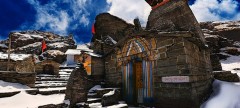
Kinnaur Temple: It is a two storey temple of Kinnauri culture at Sewa which is very different from its surrounding.
Views of Kinner Kailash: You will get mesmerized by the views of lofty Kailash Peak while you reach towards the end of Rupin Pass trek.
Get engaged with TTH Team to make the best of this adventurous journey, we will ensure that no essential task to be left out while taking care of your safety on the suddenly variably trek.
Brief itinerary
Day 1 :- Dehradun to Dhaula
Day 2 :- Dhaula to Sewa
Day 3 :- Sewa to Bawta
Day 4 :- Bawta to Jakha
Day 5 :- Jakha to Dandreyash Thatch
Day 6 :- Dandreyash Thatch to Upper Waterfall
Day 7 :- Upper Waterfall to Rupin Pass to Ronti gad
Day 8 :- Ronti gad to Sangla
Who Can Go
Detailed Itinerary
Day 1 : Dehradun to Dhaula
On the first day of your journey, you don’t have to trek but ride your way on vehicle to Dhaula. The weather on the route will not be very cold though humid, but the pleasant sights of the hills will keep up your enthusiasm for the more beautiful sight ahead. The roads till Dhaula are in good condition except the last few kilometers where a narrow uneven patch is filled with mud.
On your route, you will able the see the clean water of Yamuna river flowing, pass through a unique village, myth logically known for the worshipping of Kaurawas there. The charming among the villages is Mori, at tons valley meadows of marigold flowers are stretched. After your 8 hour ride, TTH team will serve you with delicious meal to regain your energy.
Day 2 : Dhaula to Sewa
Though your today’s trail is as long as 11 kms, yet it will not be very tiring for you, as the whole trek is an easy walks on undulating paths till Sewa. Pass a cattle shelter after exiting the Dhaula village, the trail starts climbing for about 200 mts. after 20 minutes it becomes easy again, a little further walk and your will have another different sight of Rupin flowing below into its bed.
Another scenery of Rupin falling from a high cliff, awaits you after a turn, then again trekking on an ascending trail through the apple and apricot trees, you will reach a road just before Sewa, you can have tea and snacks at the shop available there and enjoy the sights of Rupin flowing making soothing sounds.
Explore the famous Kinnaur Temple at Sewa, where medals and trophies achieved by villagers are hanging outside the temple. You will get a bit disappointed at Sewa as the sights are not as pleasing as earlier. Nevertheless, you can either choose to camp at the campsite outside Sewa, or at the Village only. You will be camping between rocks that will definitely give a feel of staying on the beach.
Day 3 : Sewa to Bawta
TToday's trek increases gradewise from moderate to difficult slowly. Our team will instruct you for the day as the area en route is prone to landslide and frequent variance in the trail is an addition to the difficulty level. After 3 hours of the moderate walk, there will be a steep ascent of 1 hour.
Your trek starts from mixed crop field and suddenly enters into a forest. A bit further walk after crossing through the thick forest you will reach near a wooden bridge which separates the two states. The bridge is known as ‘No man’s Place’ as it does not belong to any state.
After Raj Gad trail is steep ascent till Bawta. Enjoy the walking in the lovely shades of Deodar and Walnut trees. You will be resting in tents after the long walk.
Day 4 : Bawta to Jakha
Today you will be crossing the highest and the last village of this trek. Plus the trail will be continuous ascent for 4-5 hours. So embrace all the energy before beginning on the jaunt on the zig-zag mixed trail.
After a moderate ascent till Jiskun there will be a slight descending trail. You can find a wooden bridge between the dense forest. The route magically gets ascending in zig-zag fashion from the bridge. Refill your bottles at Selwan Khad as this is the last water point of today. Do not worry, there are many tea shops on the way for more water. Rest in your peaceful tents at night.
Day 5 : Jakha to Dandreyash Thatch
Waking up at the campsite near Jhaka Village is sheer bliss. The trail is well defined, passes through the field of Jhaka village, enters a forest where trees of fir standing tall depicting centuries old, pristine civilization. A turn in the trail past crossing the forest and landscapes changes itself to snow patches. Follow the snow bridge over Rupin, cross the bridge and a walk on a narrow trail till another wooden bridge.
Half an hour more walk on the boulders and hoping through the streams flowing within the rocky paths along the left of Rupin, you will enter another forest, on which rest the Rhododendron trees of a different colour.
Another walk of a few kilometres and you are at Saruwas Thatch. Relax well and admire the nature’s different shades on the perfect campsite, a serene u shaped valley in the middle of trees, with the sight of Rupin waterfall far away. Following this is the route filled with snow patches on the mountainside. The sacred silver birch trees (Bhoj Trees) will accompany you till the entrance of forests. Move upwards through the forests and you will find yourself at the verge of U shaped valley. The enchanting sights from the lip of the valley, thousands of waterfalls rushing down below you is all a set to hypnotize you for a movement.
Move downward to reach down to the valley though green and yellow meadows, after crossing a series of snow-bridges and you are in the middle of a valley, Dhanderas Thatch.
And get ready to relax and then indulge in some fun activities organized by our to enjoy one of the most admiring and biggest known meadows of Himalayan Range.
Day 6 : Dhanderas Thatch to Upper Waterfall camp
The altitude from Dhanderas to Upperwater fall camp is about 4000 mts., is enough to make you vulnerable to AMS, as it will not be possible for you to get acclimatized through the altitude in one go. TTH Team will arrangements for your acclimatization at two levels one at Dhanderas Thatch and next will be at top of water fall which is approx 1500 mts above.
TTH team will also take a short session to teach you the skills of trekking in snow such as sliding on snow, side steeping and cutting though the snow. After proper acclimatization you need to reach the base of Dhanderas, from there trek crossing through many rivulets of Rupin, make your way to the snow patch of first waterfall though the marigold flowers. A Steady and care full walk on the rocks along the hill your can now see a trail going in between through the thick snow.
Your learned techniques will come is use as you have to cut your path to another vast snow bridge. This is the last but the Ultimate snow bridge offering you the Rupin Water coming just above head and getting down below your feet. A sharp but short climb after crossing the bridge you are all set to get relaxed and enjoy your campsite.
Day 7 : Upper water fall to Rupin Pass to Ronti Gad
Longest trail of Rupin Pass begin with a steep ascendant, with bumper gain in altitude, an hour of climbing, take left trail and discover a total different and amazing sights from the Rati Pheri campsite. The only views from Rati Pheri are of the expanse of thick snow stretched all over, making your paths through them is your next exhausting task for the day to reach Rupin Pass Gully.
TTH team will take utmost care here as the snow is very thick and the trails are not clearly defined. At Rupin Pass TTH Team will serve you with some refreshment to regain your energy for the next adventurous climb to Rupin Pass. The trail to Rupin pass is short but very uncertain and has risks of loose stones falling from above. TTH Team suggests you to walk in line carefully putting your every step forward.
Rupin Pass cut from a hollow shaped region marks the beginning of Dhauladhar Range. A bit of descendant and you are ready to experience the next adventure to slide down the snow to reach Rukti Gad. Way to Ronti Gad is a gentle walk followed by a sharp descendant. Camping at the coldest yet charming campsite amidst the mountains covered with snow.
Day 8 : Ronti Gad to Sangla Via Sangla Kanda. Over Night drive to Shimla.
Today’s trek will be a downward climb but very arduous as the trail’s altitude drops rapidly. TTH Team will take another round of bout to make you adaptable to the sharp descendant, climb your way downward with more ease without hurting your foot or knees.
The trail starts with a mild climb and then a gentle walk heading to Ronti Gad valley. After losing an altitude of about 1500 ft in height you will exit the narrow valley and opens yourself up to astounding views of Mt. Kinner Kailash. Now Rupin Pass is totally out of your view. From this point you can view your next halt I.e. Lake of Sangla Kanda with small villages settled near it. Relax at the village, enjoy the sights of the Sangla Kanda Lake.
There are many trails going to Sangla from Sangla Kanda, take the trail which passes through the forest of Blue Pines. The final trail is wide and clearly defined but descendants rapidly to Sangla, after 30 mins you will reach Baspa Village and 20 mins last climb and you are at the end of the trek journey, Sangla, you can hire any vehicle from the road of Sangla to Shimla.
How to Reach
By Air :-
Jolly Grant Airport is the airport serving Dehradun, located about 25 km from the city. There is a daily flight from Delhi to Dehradun
By Train :-
Take the overnight train to Dehradun from Delhi
By Bus:-
There is regular bus service from Delhi to Dehradun, from Delhis ISBT Kashmere Gate.
We would suggest you to take only government buses from ISBT Kashmere Gate. Private buses ply from outside ISBT and they are not trust worthiness.
Usually buses drop you at Dehradun ISBT. From there you have to come to Dehradun Railway Station


.jpg&h=380&w=650&zc=1)
.jpg&h=380&w=650&zc=1)
.jpg&h=380&w=650&zc=1)
.jpg&h=380&w=650&zc=1)
.jpg&h=380&w=650&zc=1)
.jpg&h=380&w=650&zc=1)
.jpg&h=380&w=650&zc=1)
.jpg&h=380&w=650&zc=1)
.jpg&h=380&w=650&zc=1)
.jpg&h=380&w=650&zc=1)
.jpg&h=380&w=650&zc=1)
.jpg&h=380&w=650&zc=1)
.jpg&h=380&w=650&zc=1)
.jpg&h=380&w=650&zc=1)
-1.jpg&h=380&w=650&zc=1)
.jpg&h=380&w=650&zc=1)
.jpg&h=380&w=650&zc=1)
.jpg&h=380&w=650&zc=1)
-1.jpg&h=380&w=650&zc=1)
-1.jpg&h=380&w=650&zc=1)
-1.jpg&h=380&w=650&zc=1)
.jpg&h=380&w=650&zc=1)
-1.jpg&h=380&w=650&zc=1)
-1.jpg&h=380&w=650&zc=1)
-1.jpg&h=380&w=650&zc=1)
.jpg&h=380&w=650&zc=1)
.jpg&h=380&w=650&zc=1)
-1.jpg&h=380&w=650&zc=1)

